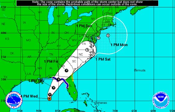
 A “tropical depression” in the Gulf of Mexico, reclassified as a tropical storm and given the clunky moniker Tropical Storm Hermine (pronounced “her-mean”) Wednesday afternoon, may be heading straight for New York City, according to a graphic released by government weather officials.
 The storm’s projected path was still very uncertain Wednesday, the National Weather Service (NWS) said.
However, an initial rendering showed Hermine headed directly toward NYC, with an expected arrival date of Sunday, Sept. 4, into Monday, Sept. 5 — aka, Labor Day weekend, aka, the weekend thousands of New Yorkers.
Hermine was expected to hit Florida by Friday.“Additional strengthening is forecast during the next 36 hours, and Hermine could be near hurricane strength by the time landfall occurs,” the NWS said.
If Hermine does continue its northeastern track along the East Coast and hit NYC over the three-day weekend, it’s unclear how strong its winds and rains would be by that time.
ABC’s local NYC station reported: “Meteorologist Lee Goldberg said if the storm stays over land, it will weaken by the time it reaches our region, but it will still be a significant event. In this scenario, we could expect Nor’easter-like weather, with a lot of rain and wind.”
As of Wednesday afternoon, the weekend weather forecast showed a slight chance of rain Saturday, then an increased chance of rain Sunday and Monday, when Hermine (or her curtails) could hit. During that time, the week’s high temps were expected to cool significantly, dipping into the mid-70s.
Even if Hermine doesn’t hit directly, the NWS has warned NYC-area coastal residents and beach-goers to watch out for “high surf and strong rip currents” while the storm’s nearby.
Images courtesy of the NWS and source
Become a Harlem Insider!
By submitting this form, you are consenting to receive marketing emails from: . You can revoke your consent to receive emails at any time by using the SafeUnsubscribe® link, found at the bottom of every email. Emails are serviced by Constant Contact


