New York City Mayor Eric Adams and NYC Emergency Management (NYCEM) today issued a travel advisory for Sunday, December 17 and Monday, December 18, 2023.
The National Weather Service (NWS) is monitoring a major coastal storm that will impact the area with a mix of moderate to heavy rain, strong to damaging wind gusts, and minor to moderate coastal flooding to the area Sunday into Monday. NWS has issued a High Wind Watch for Brooklyn and Queens for sustained winds of 25 to 35 mph and gusts up to 60 mph. NWS has also issued a Wind Advisory for Manhattan, Staten Island, and the Bronx for the same period for 20 to 30 mph winds with gusts up to 50 mph. Both the watch and advisory are in effect from 12:00 PM midnight to 12:00 noon Monday.
“With significant rainfall and high winds predicted for this Sunday into Monday, we want to remind New Yorkers to be alert, keep checking the forecast, and stay prepared,” said Mayor Adams. “If you have loose things outside, now is a good time to secure them, before the winds start. People in low-lying and poor drainage areas should take extra precautions. And today is a great day to clear your catch basins, to make sure the rain ends up in the sewers and not in our basements and streets. As always, the best way to stay safe is to stay informed — so sign up for Notify NYC to get the latest up-to-date information, directly from the city.”
“As the holiday season continues, New Yorkers commuting or traveling this week should be aware of and prepared for potential travel delays and other impacts due to the forecasted severe weather beginning Sunday night into Monday morning,” said NYCEM Commissioner Zach Iscol. “We’re closely coordinating with city agencies and utilities to mitigate any disruptions, and to respond swiftly to any incidents. For New Yorkers near the coast, please be particularly vigilant about potential coastal flooding. Please allow for extra travel time and consider using public transportation. I encourage everyone to sign up for Notify NYC for real-time updates as we work to keep our city safe and informed during these festive but potentially challenging weather conditions.”
Light rain is expected to begin Sunday morning, becoming increasingly likely in the early afternoon. Periods of moderate to heavy rainfall will continue Sunday night into Monday morning, resulting in the potential for widespread minor flooding. Thunderstorms with heavier downpours and localized flash flooding cannot be ruled out. Heavy rain may cause prolonged disruptions to transportation, particularly for the Monday morning commute, and minor flooding of basements, first floor buildings, and underground infrastructures. Heavy rain may coincide with the high tides overnight, exacerbating flood conditions along the coast. A total of 2 to 3 inches of rain with locally higher amounts will be possible. Major rainfall flooding is not expected.
Winds will be breezy during the day tomorrow but will ramp up quickly a few hours prior to midnight and will continue to increase overnight. The period of strongest winds is expected from early Monday morning to around mid-morning, with gusts of up to 60 mph possible in Brooklyn and Queens, particularly along the coastline. Elsewhere, wind gusts of up to 50 mph are expected across the western and interior portions of the city. The strongest gusts may occur with thunderstorms and heavier downpours. Scattered downed tree limbs and isolated instances of uprooted trees may cause power outages. Poorly secured objects, including holiday decorations, may be damaged or blown away.
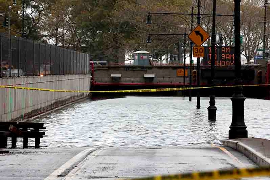
Coastal flooding is likely during high tides late tomorrow night into Monday, with higher water levels expected during the second high tide. Widespread minor flooding with one to two feet of inundation is probable late tomorrow night in the New York Harbor and Jamaica Bay. The threat of widespread moderate coastal flooding with 2 to 2.5 feet of inundation is increasing for the Monday afternoon high tide, with the highest water levels expected in southern Queens. Locally major flooding cannot be ruled out. Flooding may result in closed roadways, inundated properties, and flood-damaged vehicles. Peak tide times on Monday will be between 12:00 midnight and 1:00 AM and again between 12:00 noon and 1:00 PM. In addition, large breaking waves along Atlantic-facing beaches may cause dune erosion and over washes.
New York City Emergency Management, in response to the forecasted weather, has activated the city’s Flash Flood Emergency Plan, and coordinated calls with the National Weather Service, partner agencies, as well as infrastructure companies. New York City Department of Environmental Protection (DEP) crews have been checking flood-prone locations to ensure the functionality of catch basins and drainage infrastructure, with additional personnel scheduled for Sunday and Monday.
DEP is also prepared to manage stormwater with cleaned and inspected Bluebelts and monitor flooding on arterial highways. The New York City Department of Transportation is prepared to monitor road conditions at its Traffic Management Center and coordinate with sister agencies for flood conditions, while also assisting in clearing catch basins to prevent roadway flooding.
In addition, the Fire Department of New York (FDNY) maintains 111 water-trained rescue units, equipped for various water rescues, and 143 ladder companies with chainsaws for potential wind and tree events. FDNY’s Special Operations Command is prepared with high-axel vehicles for high water navigation and additional chainsaw-equipped units.
The New York City Department of Sanitation will be checking and servicing hundreds of catch basins citywide, with equipment ready to assist in tree-related incidents, especially if the Downed Tree Taskforce is activated. The New York City Department of Parks and Recreation is on alert to monitor tree conditions, ready to activate the Downed Tree Task Force if necessary. These efforts across multiple city departments reflect a unified and proactive approach to ensuring safety and minimizing the impact of severe weather conditions.
For access to timely and accurate updates, New Yorkers should sign up for the City’s emergency alert system Notify NYC and follow NYC Emergency Management on social media.
Safety Tips
- Allow for extra travel time. New Yorkers are urged to use public transportation.
- If you must drive, drive slowly. Use major streets or highways for travel whenever possible.
- If you live in a basement apartment in a flood prone area, prepare to move to higher ground.
- Do not drive into flooded streets or enter flooded subway stations.
- Check on friends, relatives, and neighbors, especially older adults and people with disabilities, access and functional needs, or health conditions. Help them to prepare if needed.
- Stay informed. Before and during an emergency, the city will send emergency alerts and updates to New Yorkers through various channels, including Notify NYC. Sign up for emergency notifications at gov/NotifyNYC or call 311. You can also follow @NotifyNYC on Twitter.
For more safety tips, visit NYC.gov/SevereWeather. New Yorkers are encouraged to sign up for Notify NYC, the city’s free emergency notification system, to stay informed about the latest weather updates and other emergencies. Notify NYC is available in 14 languages, including American Sign Language.
To learn more about the Notify NYC program or to sign up, visit NYC.gov/NotifyNYC, call 311, or download the free Notify NYC app for your Android or Apple device. You can now text to 692-692, using the code NOTIFYNYC, NOTIFYNYCESP (Spanish), and NOTIFYFRE (French) to be instantly enrolled to receive the highest priority, verified alerts across all the five boroughs.
You can also follow @NotifyNYC or @nycemergencymgt on Twitter.
Become a Harlem Insider!
By submitting this form, you are consenting to receive marketing emails from: . You can revoke your consent to receive emails at any time by using the SafeUnsubscribe® link, found at the bottom of every email. Emails are serviced by Constant Contact


